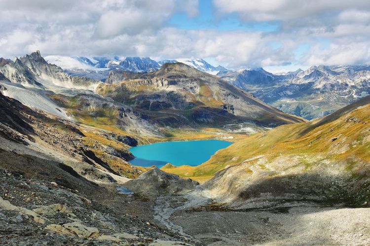
The most beautiful walks around Val d'Isère

The mountains of the Val d'Isère region offer a multitude of hiking trails for all levels, from family walks to more challenging alpine adventures. Whatever your experience or fitness level, there's a hike in Val d'Isère that's perfect for you.

For those looking for a peaceful walk with spectacular scenery, we recommend Le Lac de la Sassière and Le Vallon de Prariond. For the more experienced hiker, we recommend more challenging routes such as Le Pas de la Tovière from Val d'Isère to Tignes, Le Tour du Mont Roup and the Col de la Lose hike. These trails offer incredible panoramas, breathtaking views and challenges for experienced trekkers.

Lake Sassière

- © Marisa Estivill / Shutterstock

Easy family walks

Lac de la Sassière

A great family excursion along a path that follows the course of a small high-altitude river called the Sassière. This river is located in the Sassière nature reserve. The walk takes walkers up to a small dam at altitude, where the river's waters are held back to form Lac de la Sassière. During this excursion, hikers may be lucky enough to spot marmots moving slowly in their calm and peaceful surroundings.

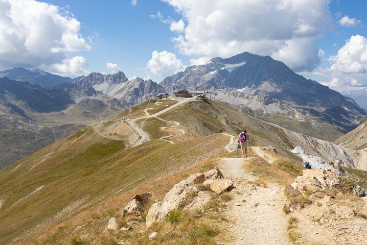
Route of the Lac de la Sassière hike

To access this trail, simply park in the gravel car park at the end of the road leading up from Lac de Tignes 2100.

The path starts to the right (east) of the car park and gradually rises, offering a breathtaking view of the Saut, a high-altitude stream. If you're lucky, you may even spot a few marmots wandering around. After reaching the Chalet de la Sassière, hikers can follow the path eastwards to reach the dam at a leisurely pace.

Once there, it is advisable to cross the dam to enjoy a panoramic view of the lake. The paths on the right leading to the Pointe de Picheru can be left to take the path on the left. Hikers will then have to cross the Sassière and Bourtes streams before reaching the Santel chalet.

Continuing west on the track, hikers can admire the magnificent scenery until they reach the small dam where a barrier marks the end of the track. All that remains is to return to the car park.

The Vallon de Prariond

For photography enthusiasts, this hike also offers great opportunities to capture the breathtaking scenery and local wildlife such as marmots, ibex and chamois. This hike takes around 1h15.

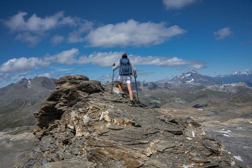
Route of the Vallon de Prariond hike

From the Pont St Charles car park, hikers are invited to take a winding path before entering the Malpasset gorges. Those prone to vertigo will need to be brave enough to negotiate a few steep passages.

Once out of the gorges, hikers can take advantage of a flatter path that leads straight to the Prariond refuge. The breathtaking scenery and wealth of local wildlife make this an unforgettable experience. Between marmots, ibex and chamois, there is no shortage of unusual encounters.

Medium hikes for good walkers

The Pas de la Tovière from Val d'Isère to Tignes

To reach Tignes from Val d'Isère, all you have to do is take the GR5, which climbs through the vast expanses of the Tovière valley and plateau. Along the way, hikers can admire the region's most iconic peaks, including the Rocher de Bellevarde, the Grande Sassière, the Dôme de la Sache and even the majestic Mont-Blanc.

Hiking between La Tovière and Col de Fresse

- © jef77 / Shutterstock

Route of the Pas de la Tovière hike from Val d'Isère to Tignes

The starting point is the Funival station, easily accessible from the Plaine de la Daille car park. Once there, take the path that runs alongside the Isère on the left bank, then take the path that climbs to the right towards the Coves power station. The path then continues through the Étroits larch forest until it reaches the GR®.

Following the GR®, hikers will be able to admire a number of sights, including the ruined hut, the Tovière altiport and the municipal swimming pool. They will also have to cross the Pas de la Tovière and the Retort, a stream that flows down from Val Claret. They will then have to walk around the tennis courts and cross a bridge to get to the Tovière cable car station.

The path then continues towards the chalets before forking left to reach the Croix de Combefolle. This picnic area offers breathtaking views of the region and also has an orientation table. Hikers can continue along the path down the Tovière valley, crossing the stream on a footbridge. This will take them back to the starting point at the Funival station.

Tour of Mont Roup

This is a beautiful, little-used walk in the Parc de la Vanoise, where you can watch marmots and see pretty streams, small lakes and waterfalls. It can be done in either direction.

How the Tour du Mont Roup hike works

The walk starts from the Manchet chairlift car park to the south of the town. From here, head south on the wide track until you quickly come to a path junction.

Turn right and leave the track to walk alongside the Ruisseau de la Calabourdane. Cross the stream on the footbridge before starting a series of switchbacks leading to a new track. Take this left to reach a new crossroads near the stream.

From here, take the right-hand branch and follow the Ruisseau du Charvet on its left bank until you reach the confluence with the Ruisseau de la Grande Tête. Continue your ascent, staying on the left bank of the Ruisseau de Charvet. Cross several streams to finally reach the right bank of the stream.

Continue climbing to reach the highest point of the route, offering a breathtaking view of Mont Blanc, before starting a short descent to a small lake. Continue downhill to the east and then south to reach the Pissets crossroads.

Change direction and head north to discover the Saut du Pisset. Continue along the left bank of the Ruisseau du Pisset past the Chalet du Riondet before crossing the Ruisseau de Charvet once again and returning to the original crossroads.

Follow the path to the right to return to the crossroads at the stream. Turn right and cross the Ruisseau du Pisset before continuing on the track. Cross the Ruisseau de la Calabourdane at the ford at Manchet to get back to the original crossroads. Take the original path to the right to return to the Manchet chairlift car park.

A difficult ride for experts

The Col de la Lose

A lovely 6-hour hike to be completed in the late afternoon, as the marmots tend to show up around 5pm. Hikers may also spot ibex and chamois.

Route of the Col de la Lose hike

The starting point for this hike is the Pont Saint-Charles, a large car park located in the first hairpin bend of the Col de l'Iseran, just after Val-d'Isère.

Hikers begin their ascent by taking a fairly steep footpath which, after a hundred metres or so of ascent, overlooks an impressive gorge. After about 1km on this east-facing path, the landscape opens out onto a green area surrounded by mountains, with the first marmots to be seen. It's near the Refuge du Prariond that hikers will really be able to spot the animals. For those who wish to stop there, the journey is 6 km round trip with 330 metres of ascent, and they may even come across a chamois in the gorges.

For the more energetic, the trail climbs a further 400 metres from the refuge, first on a winding path and then on a balcony to a plateau just above 2700m, where ibex can be seen. Hikers may also come across a few marmots along the way.

On leaving the plateau, the Col de la Galise is on the left and the Col de la Lose on the right. Hikers should take the signposted path on the right, heading south-east then north-east, leaving the small lake on their right. The path gradually climbs under the rocky ridge before turning right and finishing with an aerial passage that is not very difficult apart from the steep slope.

The return journey takes the same route.

Where to stay in Val d'Isère for hikers?

Avenue Lodge 4* Hotel Val d'Isère
Booking.com

Avenue Lodge 4* Hotel

The Hôtel Avenue Lodge is set in the heart of the famous Val d'Isère ski resort, just 250 metres from the ski lift.
8.9 Superb
From
£357 / night
Book
by Jude JONES
Need a hand? take a look at our guide
Val d'Isère
Val d'Isère
Further reading
The Grand Paradis Vanoise Nature Trek in 6 days
Val d'Isère
The Grand Paradis Vanoise Nature Trek in 6 days
Trek Nature Grand Paradis Vanoise is a project funded by the European Union as part of the ALCOTRA cross-border cooperation programme. It aims to enhance the value of the two national...
Latest news
The best places in the world to observe bioluminescence
Edinburgh
Edinburgh to the rhythm of Scottish music
Edinburgh
A literary weekend in Edinburgh
Read more articles
Best cities